Georgia DOT’s Use of an Incident Connectivity Platform Helps Reduce the Time to Locate Stranded Motorists by 85 Percent.
A cloud-based emergency call-taking platform helps better pinpoint the locations of stranded motorists.
Georgia, United States
Georgia turns to Carbyne to enhance location information for statewide transportation system
Summary Information
Previously when a stranded motorist called 511, Georgia DOT (GDOT) relied on the motorist’s sense of direction to locate them. However, often drivers do not know what they are near or even what direction they are traveling in. Additionally, motorists may be disabled in areas where there is limited camera surveillance, preventing 511 Operators from visually verifying their location.
In 2020, GDOT conducted a 3-month pilot program with 15 licenses for a cloud-based emergency call-taking app that allows traffic operations and emergency centers to quickly locate and continuously communicate with motorists with the use of its cell phone geo locate, chat, and video features. *Note that GDOT declined the use of the live video feature for this tool and had the vendor restrict that capability.
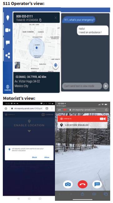
The following provides an overview of how the app works:
- A stranded motorist calls 511 and gets connected with GDOT (GDOT can receive emergency calls statewide so motorists do not have to go through 911).
- GDOT will ask the motorist for their phone number; the TMC will then send the motorist a text message that includes a link that they can click that then automatically sends their GPS coordinates back to the ATMS software.
- Motorists are given a disclaimer asking if they agree to share their location with GDOT. Once GDOT receives the location, they can dispatch the proper Highway Emergency Response Operators (HERO) or Coordinated Highway Assistance & Maintenance Program (CHAMP) unit.
The GDOT pilot program included three stages of testing. Stage 1 served as an initial baseline test for using the legacy location techniques. In Stage 2, dispatchers used the legacy procedures initially but employed the app as a backup. In Stage 3, dispatchers used the app as the initial location technology.
Findings:
- The app was found to decrease the average dispatch time from 23 minutes in Stage 1 and Stage 2 to just 3 minutes in Stage 3 (an 85 percent decrease).
- Reduced response times help reduce overall incident clearance times to get both motorists and first responders out of the roadway as quickly as possible to avoid the likelihood of any severe secondary crashes taking place at the disabled vehicle’s location.