Title
Skip to main content
U.S. flag An official website of the United States government Here's how you know
dor gov

The .gov means it's official.
Federal government websites often end in .gov or .mil. Before sharing sensitive information, make sure you're on a federal government site.

SSL

The site is secure.
The https:// ensures that you are connecting to the official website and that any information you provide is encrypted and transmitted securely.

U.S. Department of Transportation Research and Innovative Technology Administration United States Department of Transportation | Office of the Assistant Secretary for Research and Technology
Home
Intelligent Transportation Systems Joint Program Office

Callout Links

  • Benefit Data
    • About Benefits
    • Browse Benefits
    • Latest Updates
  • Cost Data
    • About Costs
    • Browse System Costs
    • Latest Updates
    • Sample Unit Costs
    • Cost Element Ranges
    • Indexes
    • Data Sources
  • Deployment Statistics
    • 2023 ITS Deployment Tracking Survey Data Repository
    • Past Deployment Tracking Surveys (1999-2020)
    • Special Topic Deployment Surveys
  • Decision Support
    • Data Visualizations
    • Benefits, Costs, and Lessons Learned Map
    • Data Stories
    • Spotlight Series
    • ROI Guide and Use Case
  • Success Strategies
    • Executive Briefings
    • Case Studies
    • Snapshots
    • Search Lessons Learned
  • Help
    • Frequently Asked Questions (FAQs)
    • Video Tutorial Library


search magnifier icon

Breadcrumb

  • Home /
  • Decision Support /

Resource Categories

Infographics
Benefits / Costs / Lessons Learned
  • Top Benefit and Cost Entries for 2024
  • ITS for High Visibility Special Events
  • Unmanned Aerial Systems (UAS)
  • ITS for Nighttime Safety
  • ITS and Extreme Weather Events: Low Visibility
  • Vehicle-to-Everything (V2X) Technology for Roadway Safety
  • ITS and Extreme Weather Events: Snow and Ice
  • ITS and Extreme Weather Events: Flooding
  • ITS for Bus Rapid Transit
  • ITS for Intersection Safety
  • ITS for Work Zone Safety
  • ITS for Parking Management
  • Micromobility Services
  • ITS for Traffic Incident Management
  • ITS for Highway Safety
  • Advancing Asset Management with Technology
  • Enhancing Pedestrian Safety with Connected Vehicle Technologies
  • ITS for Arterial Roadway Safety
  • Wrong Way Driving Systems
  • ITS Deployment Lessons Learned
Deployment Tracking Survey
  • Insights from the 2023 ITS Deployment Tracking Survey: ITS for Road Weather Management
  • Insights from the 2023 ITS Deployment Tracking Survey: Future ITS Deployment Planning
  • Insights from the 2023 ITS Deployment Tracking Survey: Dissemination of Real-Time Traveler Information
  • Insights from the 2023 ITS Deployment Tracking Survey: Fare Media and Electronic Fare Payment (EFP)
  • Insights from the 2023 ITS Deployment Tracking Survey: External Data Sources
  • Insights from the 2023 ITS Deployment Tracking Survey: Telecommunications to Enable ITS Technologies
  • Insights from the 2023 ITS Deployment Tracking Survey: Real-Time Data Collection
  • Insights from the 2023 ITS Deployment Tracking Survey: ITS Deployment on Transit Vehicles
  • Insights from the 2023 ITS Deployment Tracking Survey: ITS Technologies at Signalized Intersections
  • Insights from the 2023 ITS Deployment Tracking Survey: Connected & Automated Vehicle Technologies
  • Insights from the 2023 ITS Deployment Tracking Survey: ITS Safety Systems & Work Zone Technologies
  • ITS Deployment Tracking Survey: Geographic Coverage Expands
  • Insights from the 2020 DTS: Plans for Future ITS Investments
  • Insights from the 2020 DTS: Partnerships with Private Transportation Providers: Transit Agencies
  • Insights from the 2020 DTS: ITS Safety Systems and Work Zone Technologies: Arterial Agencies
  • Insights from the 2020 DTS: ITS Safety Systems and Work Zone Technologies: Freeway Agencies
  • Insights from the 2020 DTS: Trends in Traveler Information Dissemination: Transit Agencies
  • Insights from the 2020 DTS: Trends in Traveler Information Dissemination: Freeway and Arterial
  • Insights from the 2020 DTS: External Data Sources: Freeway and Arterial Agencies
  • Insights from the 2020 DTS: Data Collection and Use: Transit Agencies
  • Insights from the 2020 DTS: Arterial Management Survey
  • Insights from the 2020 DTS: Freeway Management Survey
  • Insights from the 2020 DTS: Transit Management Survey
  • Insights from the 2019 Small Urban and Rural Transit Survey (RTS)
  • Insights from the 2019 CV/AV Survey
Other
  • Connected Vehicle Pilot Deployment Program
  • ATCMTD Grant Program
Cost Plots
  • Roadside Detection (RS-D) Machine Vision Sensor at Intersection (Camera Only)
  • Roadside Detection (RS-D) Machine Vision Sensor at Intersection or Video Detection System
  • Roadside Detection (RS-D) ESS or Weather Monitoring System (2025 Update)
  • Roadside Information (RS-I) Dynamic Message Sign with Installation (2025 Update)
  • Roadside Information (RS-I) Dynamic Message Sign - Portable (2025 Update)
  • Roadside Telecommunications (RS-TC) Conduit Design and Installation - Corridor (2025 Update)
  • Roadside Telecommunications (RS-TC) Fiber Optic Cable Installation (2025 Update)
  • Roadside Detection (RS-D) Remote Traffic Microwave Sensor on Corridor (2025 Update)
  • Roadside Detection (RS-D) CCTV Video Camera (2025 Update)
  • Roadside Control (RS-C) Signal Controller and Cabinet (2025 Update)
Interactive Visualizations
  • Traveler Information and Mobility Innovations for High-Visibility Events
  • ITS for Curbside Management
  • Map of Selected ITS Deployments for Roadway Safety
  • Map of Selected Road Weather ITS Deployments
  • Map of Selected Work Zone Safety Deployments
  • Timeline of Selected Work Zone Safety Deployments
  • Map of Selected Pedestrian Detection Technology Deployments
  • Timeline of Selected Pedestrian Detection Technology Deployments

Benefits, Costs, and Lessons Learned Map

Decision Support

Infographics

First page of infographic depicting ITS for road weather management for freeway and arterial management agencies.
Insights from the 2023 ITS Deployment Tracking Survey: ITS for Road Weather Management
PDF
05/09/2025
Infographic
Weather
	Infographic depicting future ITS deployment planning for freeway, arterial, and transit management agencies.
Insights from the 2023 ITS Deployment Tracking Survey: Future ITS Deployment Planning
PDF
05/09/2025
Infographic
Public Transportation, Traffic Management
First page of infographic depicting Dissemination of Real-Time Traveler Information for freeway, arterial, and transit management agencies.
Insights from the 2023 ITS Deployment Tracking Survey: Dissemination of Real-Time Traveler Information
PDF
05/09/2025
Infographic
Public Transportation, Traveler Information
View All Infographics

Cost Plots

Machine Vision Sensor at Intersection (camera only) Scatter Plot
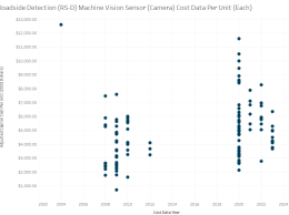
Roadside Detection (RS-D) Machine Vision Sensor at Intersection (Camera Only)
PNG
05/27/2025
Cost Plot
Traffic Management
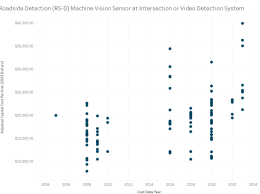
Roadside Detection (RS-D) Machine Vision Sensor at Intersection or Video Detection System
PNG
05/27/2025
Cost Plot
Traffic Management
Roadside Detection (RS-D) Environmental Sensing Station or Weather Monitoring System Scatter Plot
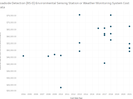
Roadside Detection (RS-D) ESS or Weather Monitoring System (2025 Update)
PNG
10/24/2023
Cost Plot
Weather
View All Cost Plots

Interactive Visualizations

Screenshot of an interactive visualization showing traveler information and mobility innovation solutions for high-visibility events, including adaptive signal system, managed lanes, and more.
Traveler Information and Mobility Innovations for High-Visibility Events
PNG
07/17/2025
Interactive Visualization
Traveler Information, Traffic Management
Screenshot of an interactive visualization showing curbside management solutions, including curbside delivery reservation, demand-based pricing, autonomous service robots, drone deliveries, smart curb parking and enforcement, and digitized curb data. Visuals include trucks, drones, robots, and icons representing each feature.
ITS for Curbside Management
PNG
10/24/2024
Interactive Visualization
Commercial Vehicle Operations, Data Management, Parking Management
Map depicting selected deployed roadway safety ITS in the United States.
Map of Selected ITS Deployments for Roadway Safety
PNG
12/27/2023
Interactive Visualization
Vehicle Safety
View All Interactive Visualizations
ITS Deployment Evaluation

INTELLIGENT TRANSPORTATION SYSTEMS JOINT PROGRAM OFFICE

1200 New Jersey Avenue, SE
Washington, DC 20590

its.dot.gov

Focus Areas 

Benefit Data

Cost Data

Deployment Statistics

Decision Support

Success Strategies

ITS Taxonomy

Connect 

Help

Contact

Topics 

Commercial Vehicle Operations

Data Management

Maintenance and Construction

Parking Management

Public Safety

Public Transportation

Support

Traffic Management

Traveler Information

Vehicle Safety

Weather


U.S. Department of Transportation Office of the Assistant Secretary for Research and Technology (OST-R)
 
 
Web Policies and Notices | Careers | FOIA | Privacy Policy | Information Quality | No FEAR Act Data | Ethics
| Office of Inspector General | OIG Hotline | BusinessUSA | USA.gov | White House
 

Copyright © 2025. All rights reserved