A Cloud-Based Dynamic Warning System Can Enable Curve Warnings at Locations where Field Infrastructure would Otherwise be Costly.
Minnesota Department of Transportation Prototyped an Online Database of Rural Curve Locations Accessed by Drivers Using a Smartphone-Based Interface.
Otter Tail County, Minnesota, United States
Pope County, Minnesota, United States
Cloud-Based Dynamic Warning System
Summary Information
Minnesota Department of Transportation sponsored a research project to develop a prototype dynamic curve speed warning application using cloud-based V2I communications. The system consisted of a smartphone driver-interface that utilized a common map application interface to access curve information using cellular communications. The curve information for Otter Tail and Pope Counties was stored as an additional layer in an existing multi-state roadway inventory database. As the vehicle approached a curve in the database, the smartphone application would visually display the advisory speed, and assess the GPS speed and direction to issue an alert if the vehicle was found to be exceeding the curve advisory speed.
- Existing dynamic warning systems rely on roadside infrastructure and are often only deployed at high crash locations due to cost factors.
- A cloud-based system can be used to enable information from rural curve locations to be stored in a database and accessed by drivers using a smartphone interface. An existing infrastructure database (Geographic Roadway Inventory Tool) can also provide a means to build upon a geographic database by adding curve information in an additional layer.
- Smartphone applications can be used to track vehicle speed, location, and direction and check against an online warning database (see Figure 1).
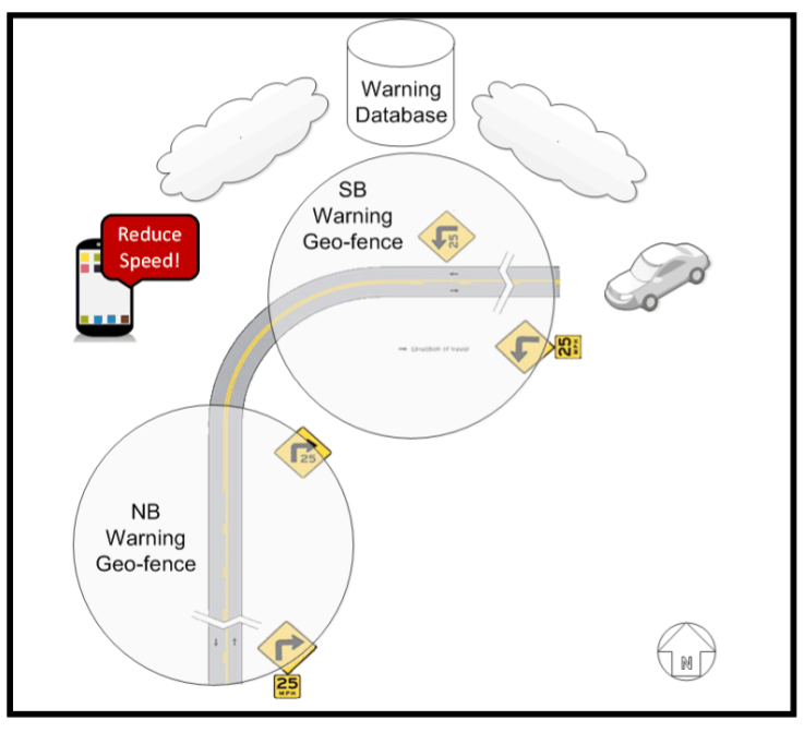
Figure 1: System Overview (Source: MnDOT)