The NYC CV Pilot project’s innovative use of lasers generated a precise, repeatable way of verifying the accuracy of a vehicle’s location in their efforts to overcome the GPS limitations of the City’s urban canyons.
How simple laser pointers became an essential tool in the toolbox for the New York City Connected Vehicle Pilot for testing vehicle location accuracy
New York City, New York, United States
New York City Connected Vehicle Pilot Uses an Innovative Approach to Verify Location Accuracy in the City’s Urban Canyons
Summary Information
Location accuracy is a key requirement for the Connected Vehicle (CV) Pilots as Vehicle-to-Vehicle (V2V) and Vehicle-to-Infrastructure (V2I) technologies are deployed into the field in larger quantities. The deployment area of the New York City Department of Transportation (NYCDOT) CV Pilot project presents challenges for GPS that the team has had to work hard to overcome to ensure that the in-vehicle devices can establish their locations with sufficient accuracy to utilize their CV applications.
In the City’s urban canyons, there are fewer satellites visible due to the many skyscrapers, causing the GPS signal at ground level (that is needed to derive location) to be degraded or lost, either through satellite signals being obscured or through signals bouncing off surroundings and forming multiple paths as they reach the street (or canyon floor).
To correct for this, the NYCDOT CV Pilot team is using an enhanced V2X-locate positioning engine to improve location accuracy. By measuring the time-of-flight from Roadside Units (RSU), additional location information can be fused with the GPS information to reduce the error and improve location estimates.
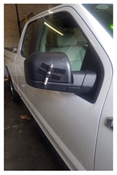
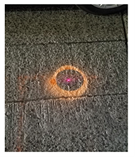
While testing these technologies, an important consideration became the repeatability of vehicles tracking a path and returning to the same location. This repeatability was addressed using simple laser pointers, tape, and temporary-chalk spray paint (water-soluble). The laser pointers were temporarily attached to the mirrors and bumpers of each vehicle (as shown in Figure 1). With the vehicle at the stop bar, the chalk spray paint was used to mark the laser point on the pavement (as shown in Figure 2). This enabled the test driver to repeatedly align the vehicle at the stop bar each trip around the block when recording the location information. Using this methodology, the NYCDOT CV Pilot team was able to verify the accuracy of the vehicle’s location using the time-of-flight information in combination with the GPS data.
(Source: NYCDOT) |
|
Using this data, the NYCDOT CV Pilot team was able to quantify the location differences between each run, measuring the deviations detected when the vehicle was located at the stop bar. The onboard unit’s (OBU) internal location information was retrieved over several runs with the vehicle located at the same point each time.