2019 Executive Briefing
 BRIEFING HIGHLIGHTS:
- The fatality rate on rural roads is more than twice that of roads in urbanized areas. The different geographical and traffic characteristics in rural areas contribute to the challenges presented by these facilities.
- Artificial intelligence is being investigated in Iowa to determine if it can effectively predict road conditions, helping support decisions made by the Department of Transportation impacting safety.
- Dilemma zone protection systems evaluated in rural parts of Maryland are helping to reduce the number of angle crashes.
Introduction
Rural areas represent 83 percent of the land in the United States and 21 percent of people, 18 percent of jobs, and 14 percent of earnings are supported by rural areas. Furthermore, there are more than three million miles of rural roads in the United States carrying 40 percent of all vehicle miles traveled. The fatality rate on rural roads is more than twice that of roads in urbanized areas [1].
| There are more than three million miles of rural roads in the United States carrying 40 percent of all vehicle miles traveled. |
Rural areas present unique challenges to both transportation professionals and transportation system users. Common characteristics and challenges faced by travelers with:
Long distance travel between towns and majority of trips over 15 miles in length
- High percentage (80 percent) of travelers drive for recreational reasons or trip purpose
- Two-lane highways where mobility can be easily disrupted by an accident or a slow-moving vehicle and where there are very few alternate routes
- Animal – vehicle collisions are common and costly
- Challenging driving conditions due to severe weather, steep mountain grades, narrow bridges, sharp curves, or wildlife near the roadway
- A large percentage of vehicles are tractor-trailers
- Gaps in wireless communication coverage
The definition of a rural area may vary somewhat based on the context, but three general classifications of rural areas emerge [2]:
- Basic Rural. These areas are dispersed counties or regions with few or no population centers of 5,000 or more. The economies in these areas tend to be predominately agricultural or natural resource based. Populations in basic rural areas tend to be stable or declining. Appalachia, the central and northern plains states, and the Rocky Mountain States all have many vast regions that can be thought of as basic rural. Tribal lands are generally basic rural in nature.
- Developed Rural. Dispersed counties or regions with one or more population center(s) of 5,000 or more, and perhaps a metropolitan area(s) with 50,000 or more. There are developed urban areas in the county or region, but there is still a significant amount of the region that is basic rural. Economies in these areas tend to be mixed industrial and service based in the cities and agricultural and natural resource based in the rural areas. Populations in developed rural areas tend to be stable or growing. Much of the Northeast, Southeast, and Midwest can be described this way.
- Urban Boundary Rural. Areas located just beyond the fringe of large urban areas. These "ex-urban" rural areas beyond the suburbs are experiencing growth across America. Travel patterns and population growth in these regions are greatly affected by the metropolitan area. In recent years, many of these areas are experiencing high rates of population growth from a low base, hence the impacts in terms of diminishing rural character.
Benefits
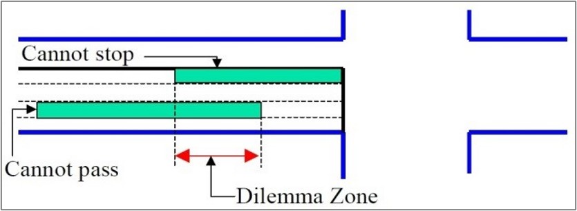
A dilemma zone protection system was developed, tested, and evaluated in two rural areas in Maryland, the results were published July 2017.
The dilemma zone refers to the area where the decision to stop for an amber signal is not clear-cut. Making an incorrect judgement can lead to side-angle and rear-end crashes. The protection system may adjust the signal timing to ensure vehicles have time to clear the intersection without conflict.
At the two signalized rural intersections where this system was tested, one near Hagerstown and the other near Elkton, Maryland, the maximum length of the dilemma zone was reduced by 30 to 40 percent (2017-01212).
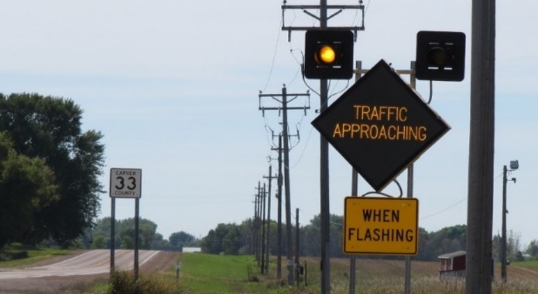
Also addressing rural intersections, the Minnesota Department of Transportation investigated the effects of Intersection Collision Warning Systems (ICWS) at five unsignalized intersections throughout Minnesota. Using video collected at both treatment and control intersections all conflicts and near-crashes were identified. The number of near-crashes observed decreased by 26 percent overall at the five treatment sites while increasing at the untreated control sites (2017-01204).
Costs
ICWS, intended to reduce the frequency of crashes by warning drivers when vehicles are approaching, as pictured in the previous section, were deployed in three states (Minnesota, Missouri, and North Carolina) as part of a pooled fund study evaluating low-cost safety strategies.
Deployments ranged in cost from $9,000 for a post-mounted system on a two-lane road to $142,500 for a post-mounted system on a four-lane road (2018-00392). The following tables summarize the cost for different deployment configurations across the three states included in the study.
| Countermeasure | Mobilization | Engineering | Construction | Design Build Oversight | Total |
|---|---|---|---|---|---|
| Post-mounted on all approaches for two-lane major approach | ~$5,000 | $11,807 | $75,650 | $17,000 | $109,457 |
| Post-mounted on all approaches for four-lane major approach | ~$5,000 | $13,130 | $103,833 | $17,000 | $138,963 |
| Intersection Type | Installation Type | Cost | Lifespan |
|---|---|---|---|
| Two-lane at two-lane intersection | Post-mounted ICWS on major approach | $25,000 to $33,000 | 10-year minimum |
| Four-lane at two-lane intersection | Post-mounted ICWS on minor approaches | ~$75,000 | 10-year minimum |
| Condition | Minimum | Mean | Maximum |
|---|---|---|---|
| Overhead on minor only | $20,000 | $29,500 | $46,000 |
| Overhead on major and minor | $20,000 | $49,000 | $78,000 |
| Overhead on major only | $13,500 | $28,000 | $49,000 |
| Post-mounted only two lane | $9,000 | $21,600 | $49,000 |
| Post-mounted only four lane | $49,000 | $117,000 | $142,500 |
Case Study
Can Artificial Intelligence Predict Winter Road Conditions?
Methodology
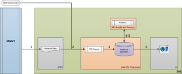
Beginning in February 2018, the Iowa Department of Transportation is developing an approach to leverage the data already collected from assets and vehicles with a focus on the I-80 corridor to predict winter road conditions using artificial intelligence (AI) [3].
Historical data collected from 2016 to 2018, including road condition, road-weather information stations, and automated weather observing systems are poured into an analytical platform powered by SAS. In this platform, these data are analyzed to produce actionable information.
Several modeling approaches were used, including regression and neural networks, before a decision tree was selected based on the number of correctly predicted road conditions. The relative simplicity of the model compared to the other approaches was also viewed as an asset.
Alongside the development of the algorithm, a user interface was developed to communicate information produced by the algorithm. During testing, it was discovered that the data provided to SAS were incorrectly timestamped, yielding some unexpected results in the visualizations that did not match real conditions at all. This experience illustrated the importance of carefully collecting, storing, and sharing data. Accurate data were -then provided, which brought the results of both approaches in alignment.
Findings
| Initial evaluation of the decision tree AI algorithm found it was accurately predicting conditions with an accuracy of 97.8 percent. |
Of approximately 242,000 road condition observations, about 237,000 were correctly classified by the decision tree model, a 97.8 percent accuracy rate. Testing the model against a storm on February 9 and 10 of 2018 found that it accurately predicted conditions in 88.5 percent of cases.
Further exploration into historical data and mis-matches between the expected and actual outcomes are underway, as are efforts to improve the usability of the user interface.
References
- “What Is Rural Transportation? Why Rural Matters.” Western Transportation Institute, Bozeman, MT. https://westerntransportationinstitute.org/about/.
- “Planning for Transportation in Rural Areas.” USDOT, Federal Highway Administration. Washington, DC. https://www.fhwa.dot.gov/planning/publications/rura l_areas_planning/page03.cfm.
- Stolle, Sinclair. "Can A.I. Take Over Winter Road Condition Reporting?" National Rural ITS Conference, October 24, 2018. http://www.nationalruralitsconference.org/wpcontent/uploads/2019/01/2018-Stolle-Can-AI-ReportRoad-Conditions.pdf.


