This case study discusses "Piloting Connected Vehicle Technology on Interstate 80 in Wyoming."
IN THIS CASE STUDY YOU WILL LEARN:
- How the Wyoming Department of Transportation (WYDOT) built a connected vehicle (CV) network to address weather-related incidents and reduce costly road closures
- How WYDOT was able to expand the benefits of CV messaging outside of the original deployment area
- How data from the WYDOT CV Pilot was leveraged to enable hands-free traveler information updates
Improving Safety on Difficult Terrain
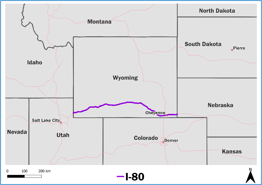
Interstate 80 (I-80) runs 402 miles along the southern edge of Wyoming (Figure 1) and serves as a major corridor for east-west freight movement in the United States, where truck volume can make up as much as 70% of the traffic stream [1]. The elevation of the entire I-80 corridor is above 6,000 feet, increasing the frequency of severe weather events such as ice- and snow-covered road surfaces, poor visibility from fog and blowing snow, and high wind events. I-80’s geographic position combined with its daily freight traffic, provides significant safety and economic challenges for Wyoming. In a one-year period from October 2015 to September 2016, the corridor saw over 1,600 vehicle accidents and over 1,500 hours of road closures, resulting in $865 million in societal costs [1]. In 2016, the United States Department of Transportation (USDOT) awarded the Wyoming Department of Transportation (WYDOT) $4.4 million under the Connected Vehicle (CV) Pilot Deployment Program to develop and deploy a suite of CV-based applications to spur innovation among early adopters of CV technologies. The Wyoming CV Pilot deployment had the following objectives tailored to meet Wyoming’s unique transportation needs [2]:
- Reduce Crashes, Crash Severity, and Road Closures. With respect to safety issues on the corridor, the Wyoming CV Pilot deployment aimed to use the real-time connectivity that CV technology can provide to notify drivers of upcoming hazards to reduce the frequency of crashes, particularly multi-vehicle, “domino” style, chain reaction pileups. The Wyoming CV Pilot deployment also looked to address the frequency and duration of road closures on the corridor through crash reductions and by encouraging safer driving behavior.
- Improve Emergency Management. The rural nature of the corridor and the frequency of extreme weather conditions also make identification of smaller crashes critical since a lone vehicle in a minor crash can become a severe event if exposure to harsh conditions lasts for an extended period. The Wyoming CV Pilot deployment sought to improve the emergency management of the I-80 corridor through early identification of conditions and improved messaging and communication.
- Improve Truck Parking. The Wyoming CV Pilot deployment looked to improve freight drivers’ ability to find safe truck parking locations along the I-80 corridor to better meet hours of service (HOS) regulatory requirements.
- Improve Construction Activity Information. The project sought to improve traveler information on construction activities along the corridor to increase safety for travel through construction zones and more efficient scheduling of freight movements through the corridor.
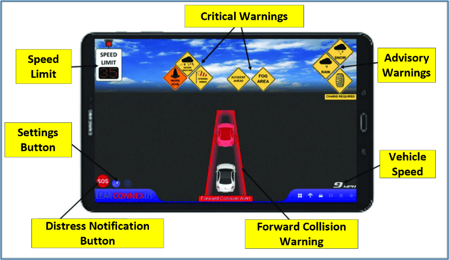
To accomplish these goals, approximately 320 heavy duty commercial trucks, highway patrol vehicles, and snowplows were retrofitted with onboard units equipped with Dedicated Short-Range Communications (DSRC) that allowed vehicles to receive and broadcast CV messages [3]. A tablet-based Human-Machine Interface (HMI) installed in the vehicles communicated information to drivers such as inclement weather warnings and advisories, recommended speeds, road closure notifications, parking/services information for trucks, vehicle restrictions, etc. (Figure 2). Mobile weather sensors installed onto WYDOT patrol vehicles and snowplows also allowed these vehicles to transmit weather data to WYDOT’s Traffic Management Center (TMC), further improving the ability to detect and forecast road weather and pavement conditions.
Breaking New Ground Using Dual Communications
Media Like many rural areas, Wyoming’s I-80 corridor lacked widespread communications infrastructure. With the Wyoming CV Pilot’s deployment area covering over 400 miles, it was cost prohibitive for WYDOT to install DSRC communication equipment along the entire corridor. WYDOT installed a limited number of DRSC roadside units along the corridor’s critical points (each with up to a 1,000-meter radius of coverage) and relied on satellite communications for segments of the corridor that were outside the range of the roadside units. Pilot vehicles were also equipped with dual-mode receivers that enabled both DSRC and satellite communications. The use of satellite communications ensures that the Wyoming Pilot can remain operational well into the future.
With the use of satellite communications enabling Wyoming to have full coverage of I-80 for CVs traveling on the corridor, WYDOT took this opportunity to expand the coverage of CV messaging even further. In 2020, WYDOT integrated Traveler Information Messages (TIM) into the operations of WYDOT’s TMC in Cheyenne [4]. This allowed CV drivers to receive TIMs while on all state and federal highways in Wyoming without any additional hardware investments and only limited software updates to the existing WYDOT applications. The expansion of TIMs statewide also proved helpful in attracting interest from potential fleet partners.
Fostering Public-Private Partnerships
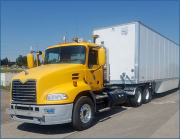
As part of the pilot, WYDOT forged new partnerships with several trucking companies, which used the CV technology as part of their revenue operations (Figure 3). Working with large semi-trucks presented unique challenges for the Wyoming Pilot. WYDOT wanted to avoid approaching commercial partners until the technology was 100% deployment-ready, since the trucks were on tight schedules that required minimizing the time that the vehicles would be out of commission for installation.
| Wyoming DOT worked to install and test the CV devices on a “friendly fleet” prior to approaching commercial partners. |
After this initial testing, WYDOT began engaging potential freight partners in discussions to clarify requirements of participating in the pilot (e.g., the need to drill holes in trucks) as well as to understand freight partners’ contractual obligations that could cause issues (e.g., leasing contracts that did not permit holes to be drilled in trucks).
WYDOT modified their installation approach to better accommodate and utilize the resources of their freight partners. Some equipment installation was completed by trucking companies after initial training from WYDOT. WYDOT continued to provide technical support to ensure that the installations were done correctly.
Working with semi-trucks also introduced a new challenge related to continuous wireless communications not experienced with the “friendly fleet” vehicles. During initial installation and testing with the antennas mounted on the roof of the cab, WYDOT found that the large box trailers were “blocking” signals from the tractor-trailer units, making forward collision warnings for vehicles coming from behind the tractor-trailer ineffective [6]. To alleviate this effect, the Wyoming team worked with USDOT’s communication experts to test various antenna positionings for proper line of sight. The testing found that the optimal antenna location to prevent signal degradation on the semi-trucks was on the side mirrors (as opposed to being on the rooftop for light-duty vehicles) [6].
Developing Innovative Applications to Expand Public Access to Traveler Information
For WYDOT, integrating and using data from CVs into the TMC was an essential part of their deployment. The TMC is the host of traffic operations-related data as well as the communication tools used to send information to third parties, such as Wyoming 511.
| The WYDOT Pilot used two open-source systems to manage the data and applications for the pilot: the Operational Data Environment (ODE) and Pikalert [4]. |
WYDOT leveraged existing open-source software to integrate CV data into the TMC, saving significant development time and yielding a more robust system that leveraged previous experience. Examples of software components that were incorporated into the project included the USDOT Joint Program Office’s (JPO) Operational Data Environment (ODE) and the National Center for Atmospheric Research’s forecasting system Pikalert® [4]. These systems helped translate the raw CV data, such as Basic Safety Messages and weather data, into discrete, useful information for TMC operators.
The project also encouraged development of new applications to further expand the visibility of the WYDOT CV data. The Wyoming project team worked to develop a centralized data retention and distribution source for the CV data called the Situation Data Exchange (SDX) that was based on USDOT’s prototype Situational Data Warehouse (SDW). Seeking ways to make the CV data available to the general public, WYDOT used data distributed by the SDX to integrate Wyoming 511 with virtual assistant technology. Through this venture, the same road information that WYDOT shares on their 511 website and phone app regarding road closures, winter conditions, and road construction is now available for anyone to access hands-free at home through voice commands [7]. As Original Equipment Manufacturers (OEMs) have started to integrate virtual assistant technology into their newer vehicle models, many travelers can also access current roadway information while driving.

The virtual assistant integration allows drivers to get the most up-to-date information, without having to take their eyes off the road. Once enabled (virtual assistant video instructions linked on right), a handler accepts the information and queries the SDX to find all TIMs contained along the existing route to the driver’s destination. Results are then translated into corresponding road conditions and read back to the user, allowing drivers to better prepare for their roadway travels. WYDOT has plans to expand the availability of voice-activated 511 reports to Apple’s Siri and Google Assistant.
As other Departments of Transportation continue to adopt the SDX to relay road information to drivers, the Traveler Information feature’s list of supported states continues to grow. “The sharing system we designed is set up so that it can support any number of states, and we’re in talks with California and Colorado and a few other states to start getting their data in as well,” said Shane Zumpf, WYDOT CV Pilot Application Development Lead. “Our vision for this is that all 50 states will start sharing their data so that the skill can be used nationwide” [7].
References
[1] ITS JPO, “Connected Vehicle Pilot Deployment Program: Wyoming 2016." [Online]. Available: https://www.its.dot.gov/factsheets/wyoming_cvpilot.htm
[2] Wyoming Department of Transportation, "Connected Vehicle Pilot Deployment Program Phase 1, Concept of Operations (ConOps), ICF/WYDOT [Phase 2 Update]," 2020. [Online]. Available: https://rosap.ntl.bts.gov/view/dot/41917
[3] ITS JPO, "CV Device Deployment Status," 2022. [Online]. Available: https://www.its.dot.gov/pilots/status.htm
[4] ITS JPO, "WYDOT CV Pilot Expands Traveler Information Messages Statewide," 2020. [Online]. Available: https://www.its.dot.gov/pilots/wydot_travel_information.htm
[5] Kate Hartman, "Wyoming DOT Connected Vehicle Pilot Deployment Program Phase 2," 2017. [Online]. Available: https://favsummit.com/pdfs/kate-hartman_wydot.pdf
[6] ITS JPO, "Wyoming DOT (WYDOT) Connected Vehicle Pilot Determines Appropriate Tractor-Trailer Antenna Placement and Equipment Configuration," 2018. [Online]. Available: https://www.its.dot.gov/pilots/wyoming_antenna.htm
[7] Wyoming Department of Transportation, "Want Wyoming Road Conditions? Ask Alexa," 2022. [Online]. Available: https://www.dot.state.wy.us/news/want-wyoming-road-conditions--ask-alexa


