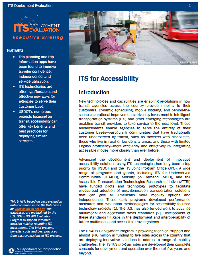
ITS for Accessibility
2021 Executive Briefing
BRIEFING HIGHLIGHTS:
- Trip planning and trip information apps have been found to improve traveler confidence, independence, and service utilization.
- ITS technologies are offering affordable and effective new ways for agencies to serve their customer base.
- USDOT’s numerous projects focusing on transit accessibility can offer key benefits and best practices for deploying similar services.
Introduction
New technologies and capabilities are enabling revolutions in how transit agencies across the country provide mobility to their customers. Dynamic scheduling, mobile booking, and behind-thescenes operational improvements driven by investment in intelligent transportation systems (ITS) and other emerging technologies are enabling transit providers to take service to the next level. These advancements enable agencies to serve the entirety of their customer bases—particularly communities that have traditionally been underserved by transit, such as travelers with disabilities, those who live in rural or low-density areas, and those with limited English proficiency—more efficiently and effectively by integrating accessible modes more closely than ever before.
Advancing the development and deployment of innovative accessibility solutions using ITS technologies has long been a top priority for USDOT and the ITS Joint Program Office (JPO). A wide range of programs and grants, including ITS for Underserved Communities (ITS4US), Mobility on Demand (MOD), and the Accessible Transportation Technologies Research Initiative (ATTRI) have funded pilots and technology prototypes to facilitate widespread adoption of next-generation transportation solutions that can give all Americans more mobility options and independence. These early programs developed performance measures and evaluation methodologies for accessibility focused technology projects [1]. The U.S. has also funded work to advance multimodal and accessible travel standards [2]. Development of these standards fill gaps in the deployment and interoperability of future multimodal and accessible travel systems.
The ITS4US Deployment Program is providing technical support and almost $40 million in funding to five sites across the country that are deploying innovative solutions to address a range of mobility challenges. The ITS4US program sites are developing their complete concepts for deployment and operation over the next five years and beyond.
Although these ITS4US programs are still in the process of refining their concepts and preparing for deployment, the experience from other USDOT initiatives allow a clear look at the ability of ITS systems to provide next-generation service to all customers, positively impacting every part of travelers’ journeys, from trip planning to successful trip completion.
Benefits
Information Access
One of the key advantages of integrating ITS technologies into a transit system is the capacity for agencies to provide better dynamic trip information to their customers. Rather than relying on a static timetable, riders can see dynamic locations of transit vehicles reported by an automated vehicle location (AVL) system and can receive live updates in case of a delay or rerouting. This information is not only convenient to travelers, but it also expands the accessibility of transit services. Customers can be more confident in taking trips, knowing in advance where their vehicle is and whether they will arrive at their location on time, enabling independent travel.
A recent market research report performed for Arlington County, Virginia conducted focus groups and a panel survey with more than 450 stakeholders (including end users) to gain insight into how and where real-time transit information (RTTI) fits into the transit user experience. Key benefits to travelers include the following: (2020-01003)
- Almost all riders of Arlington Transit (ART), the bus service in the county, reported that they found the County’s website offering RTTI valuable through increased ability to access RTTI.
- Nine in ten respondents reported being mostly or completely satisfied with the live transit and route updates currently being displayed on LED message boards. These boards represent cost-effective ways of communicating with riders.
- The report found that most participants were highly versed in usage of their mobile phones. While Arlington may not be representative of all counties, the ubiquity of smartphones means that applications designed for mobile devices can reach more customers than ever.
- Respondents across all demographics noted that RTTI was helpful and convenient, reducing wait time, helping users to relax, and impacting their mode choice. For example, users with easy access to subway train times noted that their access to the information informed the decision to take transit over other modes.
Partnerships
A popular method for agencies to reduce costs is through the formation of public-private partnerships (PPPs). These partnerships can come in a wide variety of forms—for example, Boston’s MBTA on-demand paratransit service, The RIDE, has introduced a service called The RIDE Flex that allows paratransit users to book RIDE trips through private ridesharing platforms and receive fare subsidies [3]. By redirecting users that may prefer this booking system, the MBTA can reallocate its resources to providing trips to other users, such as those that require wheelchair-accessible vehicles (WAVs) and driver assistance that cannot be guaranteed by the ridesharing platforms.
In this way, MBTA can ensure that it can work towards its goal of providing effective, equitable access to transportation for all its users with lower overall expenditures. While the evaluation of the full deployment has yet to be released, early results from the pilot were promising. There was a demonstrated a 30 percent increase in trip volume with lower overall spending, agency cost savings of up to 85 percent on each ride, and strong improvements in customer satisfaction (2019-01342).

Other successful PPPs include partnership with private route-planning applications. Agency-specific applications can be expensive to create and maintain, and often require regular maintenance and technical support. The Los Angeles Metro, which services nearly 10 million people, moved from an in-house application for trip planning and coordination, to a third-party app (2020-01491). The implementation of the new app is expected to save the agency $240,000 per year in app maintenance and development costs and that has no associated contract costs. The new app will further support accessibility features to assist riders with visual disabilities, improved information reliability and consistency, and allow for personalized service alerts for travelers.
Pre-Trip and Concierge Services
The ATTRI program conducted research to better understand the needs of travelers with disabilities, synthesizing a set of user needs and a performance measurement evaluative framework intended to serve as a reference for agencies seeking to improve their accessible transportation services [1, 4]. Many of these needs were distilled from five projects, to which ATTRI collectively awarded more than $6 million, which identified and developed transformative transportation applications for users with disabilities. The project team developed and evaluated a suite of cognitively-accessible tools called the Smart Travel Concierge System (STCS). This system was designed to assess and train trip-taking skills, allowing users to virtually experience trips to better develop pre-trip preparation activities and to enable users to have greater independence by making travel safer and more comfortable for them (2021-01573).
To evaluate the system, the project used a pre-test/post-test study to measure changes in travel readiness knowledge, giving the assessment to 23 volunteers with cognitive disabilities. The findings from the evaluation were positive:
- The self-directed training modules were demonstrated to improve vehicle identification scores among users by 9 percent.
- Users of the apps were able to complete 14 percent more pre-trip preparation tasks, and 11 of 12 testers started and finished a trip on time with the help of the apps compared to only 5 of 12 testers who were not using the apps.
- Testers who participated in the Special Media for Assisting Route Travel (SMART) Wayfinding travel project, a suite of wayfinding tools that the STCS was designed to work with, showed a 14 percent increase in “Transportation Readiness” score.
Costs
In 2016, the FTA, in partnership with the ITS JPO, launched the Mobility on Demand (MOD) Sandbox program, distributing a total of $8 million to 11 different sites across the country. The MOD Sandbox focused on the development and demonstration of innovative transit integration concepts, assisting transit agencies using ITS solutions to better coordinate their services and ensure that affordable and accessible transportation options were available to users.
Portland’s Tri-County Metropolitan Transportation District of Oregon, or TriMet, shared a detailed breakdown of how its funding was allocated [5]. The project expanded the Open Trip Planner (OTP), an open-source project allowing data feeds to incorporate biking and pedestrian networks with transit. The MOD Sandbox project was designed to create an open platform supplementing existing functionality with shared-use mobility modes, giving users access to better information as they planned and scheduled their trips. The introduction of a new, fully functional geocoder format—a method for returning geographic coordinates for entered locations—also enabled cheaper, easier implementation of similar initiatives by other agencies, allowing for significant cost savings. The expanded TriMet trip planner supports enhanced accessibility information and ensures that the application is more user-friendly and convenient for those seeking to plan and execute trips.
TriMet reported an additional $40,000 in in-kind contributions over the $962,000 in federal funds, giving a total funding amount of over $1 million. In its final project report, TriMet indicated how different funds were allocated as seen in the table below.
| Task | Total Budget |
|---|---|
| Project Management | $138,500 |
| Evaluation and Reports | $90,000 |
| Application Development | $360,000 |
| Geocoder Development | $244,000 |
| Data Improvements | $51,500 |
| Integrated Payment Plan | $100,000 |
| Travel and Incidentals | $18,000 |
| Total | $1,002,000 |
Best Practices
The Pierce County Public Transportation Benefit Area Authority in Washington State was one of the selected MOD Sandbox sites. Their project, Limited Access Connections (LAC), established a three-pronged approach to cover gaps in the transportation network: partnering with ridesharing partners, guaranteeing rides during service gaps, and providing trips to and from park-and-ride lots (2021-01037).
The LAC project collected data from over 8,800 trips over the 19-month pilot period. A user survey was also distributed to collect rider impressions and to better understand the perspectives of users. These inputs were used to draw the following insights into key best practices and lessons learned from the operation of the pilot:
- Communication with staff at other agencies is key to form partnerships and to foster best practices for project design.
- Review transportation network company (TNC) and transit partnership documentation to form templates for agreements, policy development, and operational guides.
- Ensure that partners agree early in the process to the type, granularity, and amount of data necessary to measure performance and demonstrate success.
- Be sure to involve legal counsel where necessary to understand the rights, risks, and responsibilities of partners that will be creating, storing, and sharing data.
Another MOD Sandbox project was conducted by Valley Metro of Phoenix, Arizona (2021-01036). The project created a “Mobility Platform” updating their previously developed mobile application with innovative features such as mobile ticketing and payment and integration with multiple public and private transportation options. A survey of 332 participants collected pre- and post-usage feedback and impressions. These findings were used to synthesize the following best practices on project planning, user engagement, and data collection:
- Plan wisely to reduce the risk of participant attrition. The project recommended recruiting twice as many participants as would be needed to establish a minimum statistically viable sample to reduce the impact of having users drop out of a pilot program before the end of the evaluation.
- Develop strategy with potential partners at the beginning of the project to enhance capability and clearly outline partnership parameters. Engaging technical expertise from experienced support staff where appropriate or necessary can ensure that a pilot can proactively address potential challenges rather than needing to react to them.
- Actively share knowledge between agencies. By communicating with other agencies who have completed or plan on launching similar pilots, a deploying agency can reduce or eliminate potential redundant work.
Case Study
The AccessPath project, part of the ATTRI program, focused on developing a mobile app capable of providing turn-by-turn wayfinding instructions to users with an emphasis on pedestrian navigation and monitoring of obstructions such as construction barricades or deteriorated curb cut-outs that would not be reported on existing route-planners [7]. By maintaining an internal database of sidewalk quality and crowdsourced reports of obstructions or hazards, the app can alert users to potential obstacles and adjust to a user’s specific comfort and ability level. Users can also manage and save “favorite” routes to ensure consistency with their travel, and the app provides voice-over capability to annunciate turn instructions to users without requiring visual navigation.

Features were integrated into AccessPath with an emphasis on user needs and focus-grouped suggestions from users. This ground-up approach to accessibility was designed to ensure that key design components would be useable by as many travelers as possible. As part of these roundtables and focus groups, collectively surveying more than 30 members of target demographics, the project was able to highlight key priorities for travelers with disabilities, noting that the following items were particularly prioritized: (2021-01563).
- All respondents who used wheelchairs indicated that identification of accessible entrances was of the highest priority.
- Among all respondents, the three highest-priority features were a map legend, rerouting capability, and haptic alerts.
- Respondents who were blind or had low vision requested features such as “more info” buttons, bus pre-arrival alerts, and haptic interaction with their devices.
- Other features identified as helpful by the overall group of respondents included an “emergency button,” transit accessibility notes, and indoor accessibility.
Ultimately, the project developed smartphone apps for both Android and iOS, an API allowing other developers to implement the project’s major components, and data collection in three different cities to facilitate routing. The project team discussed steps to enable future developers to easily build off their work, facilitating future developments and expansion of the concept. The team also collected lessons learned for developing accessibility software through the activities of the project, including the following:
- Data accuracy is critical. While open data sources can be helpful in filling gaps or getting started, sourcing can be opaque, and the quality of the data may not be as reliable as is necessary for all applications. This can be a particular challenge for accessibility-related datasets such as sidewalk navigability, which requires particularly reliable, up-to-date information and may not be already collected by agencies. Crowdsourcing data can help to meet this challenge.
- Feature priority must be managed to avoid scope inflation. While all the features suggested by the focus groups to improve the app’s accessibility were constructive and would be beneficial if implemented, the project team developed a prioritization list to ensure that development time could be spent on the most impactful items, leaving lower-priority items for future efforts.
- Testing protocols are vital to the development process. They allow end users and advocates to be involved in the project during the entire process, ensuring their voices will be heard and their needs addressed, and allow for a more robust bug-fixing process.
References
- A. Caspi, M. Hallenbeck, and S. Tyman, “Accessible Transportation Technologies Research Initiative (ATTRI) Performance Metrics and Evaluation,” U.S. Department of Transportation ITS Joint Program Office, Washington, D.C., FHWA-JPO-20-784, Jul. 2020. [Online]. Available: https://rosap.ntl.bts.gov/view/dot/50748
- P. Okunieff, L. Brown, K. Heggedal, C. Schweiger, A. Chang, and K. O’Reilly, “Roadmap for Multimodal and Accessible Travel Standardization Work,” U.S. Department of Transportation, Washington, D.C., FHWAJPO-21-845, Feb. 2021. [Online]. Available: https://rosap.ntl.bts.gov/view/dot/58673
- B. Pierce, E. Plapper, J. Rizek, and Battelle Memorial Institute, “Accessible Transportation Technologies Research Initiative (ATTRI) User Needs Assessment: Stakeholder Engagement Report,” Office of Operations Research and Development Federal Highway Administration, Washington, D.C., FHWA-JPO-16- 354, May 2016. [Online]. Available: https://rosap.ntl.bts.gov/view/dot/31320
- E. Sinagra, “Development of AccessPath: A pedestrian wayfinding tool tailored towards wheelchair users and individuals with visual impairments; Phase 1 Final Report,” U.S. Department of Transportation ITS Joint Program Office, Washington, D.C., FHWA-JPO-21-846, Sep. 2020. [Online]. Available: https://rosap.ntl.bts.gov/view/dot/55240
- Tri-County Metropolitan Transportation District of Oregon and IBI Group, “Mobility on Demand (MOD) Sandbox Demonstration: Tri-County Metropolitan Transportation District of Oregon (TriMet) OpenTripPlanner (OTP) Shared-Use Mobility, Final Report,” U.S. Department of Transportation, Washington, D.C., 0197, Jul. 2021. Accessed: Jan. 19, 2022. [Online]. Available: https://rosap.ntl.bts.gov/view/dot/56479
- “Valley Metro launches new commuter ridesharing tool,” Valley Metro, Aug. 05, 2020. https://www.valleymetro.org/news/agency/2020/08/valley-metro-launches-new-commuter-ridesharingtool (accessed Jan. 19, 2022).
- “The RIDE Flex,” Massachusetts Bay Transportation Authority. https://www.mbta.com/accessibility/the-ride/on-demand-pilot (accessed Jan. 19, 2022).